Overview:
This article will detail how you can find offshore fishing spots for grouper, snapper, sea bass, hogfish, and all those other species of delicious fish that feed on the bottom of the water column. This article is geared towards locations around Florida but you can extrapolate the strategies to other locations as well.
Public Locations:
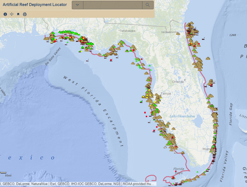
The website for Florida’s fish and wildlife department is https://myfwc.com. You can go there or search for something like “Florida reef locations” on Google which should take you to the department’s website. On that website you can find public longitude and latitude numbers and not have to worry about finding your own spots. That specific website has an interactive map, PDF documents, and Excel sheets that provide the lat/long of the public offshore locations. Now, they are public spots, so there will be other people fishing them. However, don’t be discouraged because big fish can still be caught from these locations.
Purchase a Map:
The next option for finding offshore fishing spots is to purchase a Top Spot fishing map. These maps can be purchased from most local bait and tackle stores in and around marinas. Or they can be purchased from Amazon using the links below. The states that offer these maps include Alabama, Florida, Georgia, North and South Carolina, Virginia, etc.
Florida:
Top Spot Fishing Map for Charlotte Harbor
Top Spot Map N202 Tampa Bay Area Fishing and Recreation Map Port Rickey to Venice
Top Spot Map N218 Cape Canaveral
Top Spot N210 South Florida Offshore Fishing Map
Top Spot N219 Map- Mosquito LagoonN Indian River N&S Mosquito Lagoon
Top Spot Map N204 10 Thousand Islands Florida Area Fishing and Recreation Map
Top Spot Map N223 Pensacola Area
Top Spot Map N213 Palm Beach Area
Top Spot Fishing Map from New Smyrna to Jacksonville
Top Spot Map N228 Gulf of Mexico
South Carolina:
Top Spot Map N235 South Carolina
Top Spot Fishing Map from Stono River Folly Island to Frip Island
Top Spot Map N238 Offshore Upper
Top Spot Fishing Map from Port Royal to St. Helena Sound
Top Spot Fishing Map from Stono River Folly Island to Frip Island by Top Spot
Top Spot Fishing Map from Cape Fear/Wilm to New River Inlet/Jacksonville by Top Spot
North Carolina:
Top Spot Fishing Map for Offshore North Carolina Cape
Top Spot Map N237 Winyah Bay S.C. to
Top Spot Fishing Map from Cape Fear/Wilm to New River Inlet/Jacksonville
Top Spot Map N242 Offshore N.C.
Top Spot Map N243 Offshore N.C.
Top Spot Map N240 Inshore Albemarle
Georgia:
Top Spot Map N229 Georgia Offshore
Virginia:
Top Spot Map N246 Lower Chesapeake
Top Spot N244 Map-Offshore VA Lower Coast to Upper NC Coast
Alabama:
Top Spot Fishing Map from Mobile Bay to Dauphin Island
Keep in mind that there may also be people at these spots as well since anybody can buy these maps. However, it probably is less likely than the public spots. These will show some artificial reefs and structure that you might not be able to find on the public website locators.
Finding Your Own Spots:
What you can do here is go to the public spots or the Top Spot locations and do some exploration by yourself. If it’s a nice day out or if you’re having a tough day, don’t be afraid to do some boating around and explore locations. Just keep in mind your bottom machine and fish finder while you are exploring. You can even troll while your exploring to kill two birds with one stone.
Also, don’t be afraid to ask around. Typically, your local marina will have some good ideas. You can utilize social media as well leveraging local Facebook groups for some knowledge and direction. Be careful though, you don’t want to ask people for their exact numbers because nobody wants to reveal places they fish.
Don’t forget to check out the Pro Fishing Rigs store for more cool stuff!